 Atria
AtriaScout runs your acquisition thesis across the United States and returns ranked sites with a source for every fact. Your agents ask the same questions through the Atria MCP server, and our advisory team takes the sites you choose from diligence to permit.
Run a thesis
Describe the site you need. Scout searches every jurisdiction in range and ranks what it finds.
Thesis
Atria Scout
20 to 60 acre industrial sites within a mile of high-voltage transmission and outside the floodplain, anywhere in Indiana, Ohio, Kentucky or Tennessee.
0
Parcels screened
—
Strong matches
Ranked sites
Atria Scout
46th St
Lawrence, IN, 20.7 ac
88
Sunnyside Rd
Lawrence, IN, 26.0 ac
88
4207 Michigan Ave Rd NE
Cleveland, TN, 59.9 ac
87
4405 Michigan Ave Rd NE
Cleveland, TN, 23.6 ac
82




Trusted by leading AI startups, developers & architecture firms
Scout
Write the thesis in plain language. Scout searches every jurisdiction in your target area, scores each parcel against the thesis with its reasoning written out, and opens a data room for the sites worth pursuing.
Acreage, zoning, distance to transmission, flood exposure and ownership, described the way you would brief an analyst.
Scout reads parcel records across every jurisdiction in range at once, so the shortlist covers the whole market rather than the addresses you already knew.
Each shortlisted site gets its own diligence pack, exhibits and owner contact, ready to share with your team or a seller.
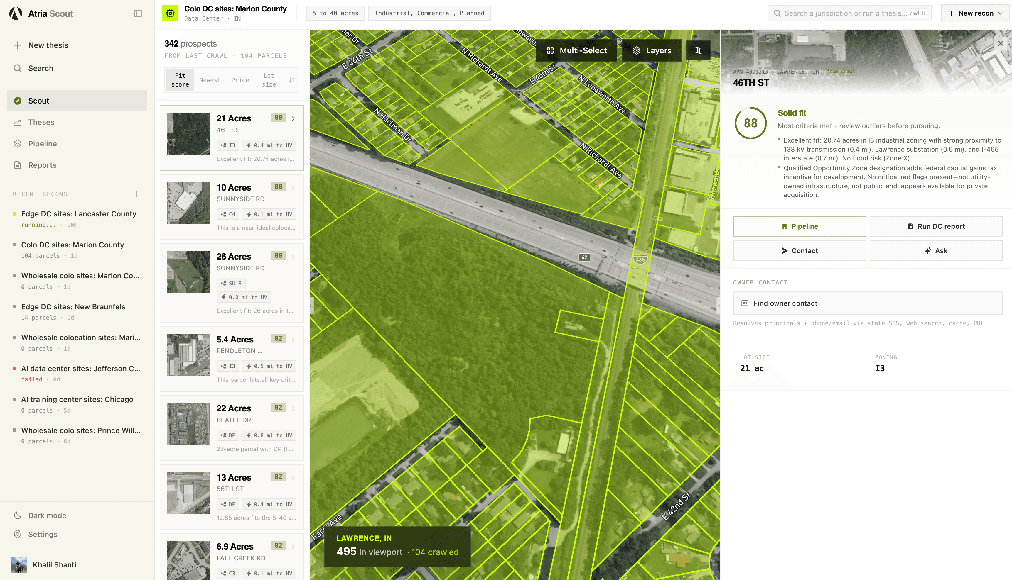
A Scout thesis run: colocation data center sites in central Indiana, ranked and outlined on the map.
Parcels evaluated
One crawl, southern DFW
Strong matches
Across 5 counties
Thesis to ranked sites
End to end
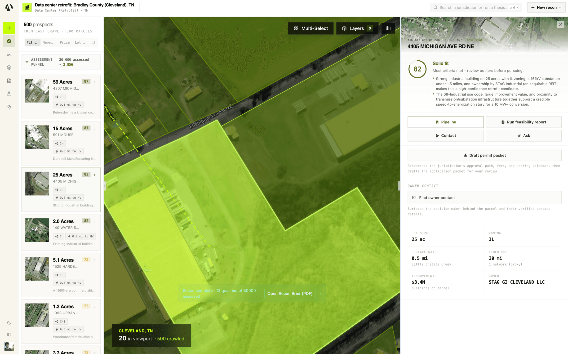
The same screens your agent can call are run on every site Scout shortlists and collected into one pack, with exhibits, owner contact and the source behind each finding.
Advisory
Engage us for a single crawl or the full pre-development arc. Our AI agents do the research; our team stays with you from the first parcel list to the hearing date.
Describe your buy-box in plain language. Scout crawls every target jurisdiction at once, scores every parcel against your thesis, and returns a ranked shortlist.
Land Acquisition Brief
Every candidate is enriched with zoning, environmental constraints, infrastructure proximity, and ownership - each claim cited to the source ordinance or record.
Cited parcel dossier
We turn constraints into a buildable envelope: development standards, setbacks, FAR and height limits, and feasibility-grade site studies your design team can start from.
Site & zoning study
Scout researches how the jurisdiction actually approves your project - the path, the board, the hearing calendar - and drafts the application packet for your team's review.
Permit packet + drafted application
Engage us for one site, one market or the whole pre-development arc.
Some of what a site decision needs is not in any public catalog, so Atria builds it. The rest comes from the public record, and every value carries its source and the date it was read.
Boundaries, owners and values read from each county's own records, fetched the first time a site there is asked about and kept current by Atria rather than licensed from a reseller.
For a parcel's zoning district, the permitted uses and the height, density, lot coverage and setback limits, read from the ordinance with the section each rule comes from. Where the rules have not been read yet, Atria reads them on request.
Where transmission and substations actually are, so distance to power reflects what is in the ground.
Where pipeline capacity is available, matched to the sites that could use it.
The owner of record and mailing address from the county's own records, so outreach starts from the party the county taxes.
Every parcel scored against your thesis, with what fits and what to check written out.
Built by Atria
Read at the source
For agents
Point any MCP-capable agent at Atria. It can look up any US address, run diligence screens on it, and search the sites Scout has already found for your team, without anyone learning a new tool.
Start from what the project needs rather than an address. Atria returns the parcels that fit, each with its score and the reasoning behind it.
Power and gas, water, flood and natural hazards, environment and habitat, terrain, soils and climate, access and airspace, connectivity, and the people and labor around a site, each a module you can ask for with its source. Where the county's zoning is mapped, the screen also returns the district's rules from the ordinance, or fetches them if they have not been read yet.
Every value is marked ok, partial, absent, failed or pending, so an agent can tell a real gap from a source that did not answer or data Atria is still fetching, and does not fill it in from memory.
You
We need at least 20 acres for a 50 MW campus in the Midwest. Check the sites Scout has already found for us, then screen the best one for flood, power and environmental records.
atria_search
state: "IN", min_acres: 20, min_score: 80
| 46th St | 20.7 ac | I3 | fit 88 |
| Sunnyside Rd | 26.0 ac | SU18 | fit 88 |
atria_screen
lat: 39.858, lng: -85.989, parcel_id: "4001213", modules: [floodZone, transmissionLines, substations, electricState, environmentalFacilities]
Agent
46th St is the stronger site. It is 20.7 acres zoned I3, outside the mapped floodplain and 0.4 miles from a 138 kV line, and AES Indiana serves it. EPA lists no regulated facilities within a mile. Each value carries its source and fetch time if you want to check it.
Atria runs as a hosted MCP server. Add askatria.ai/mcp to Claude, ChatGPT, Cursor or any MCP client and it opens your browser to sign in and approve. The tools then sit alongside everything else your agent can already do.
Add Atria to your agent
Pick your client below and run the line, or paste the URL into its connector settings.
Sign in and approve
Your client opens a browser. Sign in or create an account; the free plan needs no card.
Ask about a place
Try “Who owns 4405 Michigan Ave Rd NE in Cleveland, TN, and how much of it floods?”
npx add-mcp https://askatria.ai/mcpDetects the agents on your machine, such as Claude Code, Cursor, VS Code, Codex and Gemini CLI, and adds Atria to each. Your client opens a browser to sign in and approve; the free plan needs no card.
Any other MCP client, in its config file
{
  "mcpServers": {
    "atria": {
      "type": "http",
      "url": "https://askatria.ai/mcp"
    }
  }
}
Sign in or create an account when your client asks; the free plan needs no card. API keys for headless and server use are in your dashboard. Thesis runs need the Team plan, and one started by an agent waits for an owner on your team to approve it before any credits are charged.
Read the API docsatria_lookup
Any US address, coordinate or parcel number resolves to the parcel of record: owner, acreage, zoning, land use, assessed value and outline.
100
atria_screen
Diligence modules at any point or parcel, from flood zones measured on the outline to utility territory, the interconnection queue, adjoining parcels and the zoning district's rules.
10 national, 25 county, 400 at most
atria_screen_batch
The same screen over up to 25 points or addresses in one call.
The screen price per point
atria_ask
A question in plain language, answered from the modules it runs, with the source behind every finding.
50 plus the modules it runs
atria_proximity
Distances and drive times from a site to the places that matter to it, and the labor shed around it.
10, plus 1 per driving route; a labor shed is 50
atria_quote
The price of a call, and whether your balance covers it, before anything runs.
Free
atria_catalog
Every screen module with its fields, units and sources, and the presets that bundle them.
Free
atria_search
Query the sites your organization has found and scored, by state, area, acreage, score, owner, zoning or land use.
20 per page
atria_result
One crawled parcel with its score explanation and full diligence screen.
20
atria_coverage
Which parcel and GIS sources Atria reads for a location, and which modules are national.
Free
atria_job_status
Progress of a county Atria is still mapping, which it fetches the first time someone asks.
Free
atria_crawl_start
Run a thesis over any area you define, on Team and Enterprise. Runs asynchronously and lands in Scout.
250,000
Scout crawl
A thesis crawl started in Scout itself, on Team and Enterprise.
250,000
atria_crawl_status
Progress and result count for a running crawl.
Free
Free
$0
5,000 credits a month
Agents only. No card needed.
Builder
$49/ month
75,000 credits a month
Agents and the API, with overage at $1 per 1,000 credits up to a cap you set.
Team
$399/ month
600,000 credits a month
Adds Scout: thesis crawls, chat, data rooms, pipeline and owner outreach, on the same balance.
Enterprise
Custom
Annual agreement
For data center and energy developers: Scout seats across your organization, bulk crawls, owner outreach, data rooms, a support agreement and custom data.
1 credit is $0.001. Credits belong to your organization and reset on the first of each month (UTC).
Atria serves the full lifecycle of a land deal - from the analyst screening parcels to the architect pulling setback data to the municipality reviewing the application.
Infrastructure developers
Define your acquisition criteria once - acreage, zoning, transmission proximity, flood risk, water access - and Atria crawls every target jurisdiction simultaneously. Each parcel comes back scored with the exact data your IC deck needs.
See a demoLand brokers
Stop cold-calling from county tax rolls. Atria scores owners by fit, drafts your outreach, and generates offering memorandums from parcel data - so you spend time on relationships instead of research.
See a demoArchitects and engineers
Pull zoning districts, setbacks, FAR, height limits, parking requirements, and overlay restrictions for any parcel. Every data point traced to the source ordinance so your pre-design assumptions hold up in review.
See a demoMunicipalities and planning departments
Many smaller jurisdictions keep parcel data in CAD files and zoning on a PDF map, with no public-facing GIS, while state mandates and developer interest call for digital infrastructure they have no budget to build. Atria can help close that gap.
Talk to our government teamTell us what you are looking for. We will run the first thesis with you and connect your agent to the results.
npx add-mcp https://askatria.ai/mcpDetects the agents on your machine, such as Claude Code, Cursor, VS Code, Codex and Gemini CLI, and adds Atria to each. Your client opens a browser to sign in and approve; the free plan needs no card.